
Geophysical Research Infrastructure for Antarctica (GRIT)
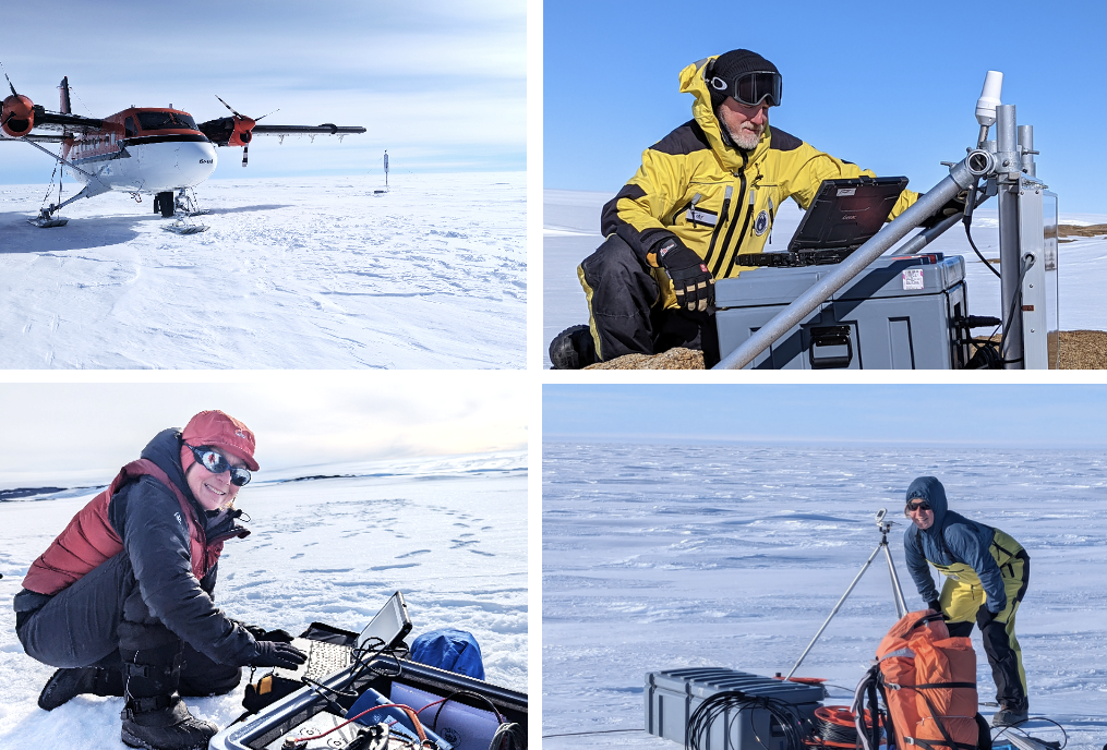
GRIT Field Deployments (clockwise from top left): Fixed-wing aircraft, Upper Vanderford Glacier seismic and MT site installation; Dr Tobias Stål, Snyder Rocks GNSS upgrade; Dr Maria (Coti) Manassero aligning an MT installation magnetometer; Prof. Anya Reading carrying out an on-site data download. Images: Anya Reading and Arno Payan (Field Guide, AAD).
The Geophysical Research Infrastructure for Antarctica (GRIT) project aims to advance Antarctic research with specialised geophysical instrumentation tailored to the continent's extreme conditions.
The GRIT Facility enabled by Phase 3 sees a major expansion to provide significant GNSS station coverage to quantify the Earth’s response to ice mass change, seismic recordings to capture deep-Earth heterogeneity and active glacier processes, and MT recordings to inform mantle viscosity and subglacial hydrology.
Phase 3 (GNSS, seismic and MT instrument sets, field deployment support, skills development, and open-source data pipelines for the nation) builds on the achievements of Phases 2 and 1 (MT instrument sets).
Overview
Led by Professor Anya Reading (University of Tasmania), together with Professor Matt King (University of Tasmania) and Adjunct Professor Kate Selway (University of Tasmania), the four-year project (Phase 3) will acquire and deploy GNSS, seismic and MT instruments, building on previous phases from AuScope and ARC funding.
In addition to acquiring an expanded range of polar-rated equipment, GRIT team members will configure the instrument sets for deployment in Antarctica using light logistics, with a trajectory to the majority of data being telemetered in near-real time. Skills development in field geophysics and field team leadership in harsh conditions are important components of GRIT Facility activities. All acquired data will be made available in open source repositories as a national resource for Australia, underpinning its contribution to the stewardship of knowledge for Antarctica.
“The present-day and future response of the Antarctic ice sheet to global change depends on hidden Earth-ice interactions; GRIT Facility instruments will enable breakthrough research to understand those critical processes”
- Prof. Anya Reading, Project Lead.
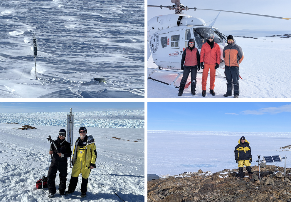
GRIT Field Deployments (clockwise from top left): Denman Glacier seismic site installation; Helicopter supported installation team on-ice seismic site Browning Peninsula; Niam Askey-Doran (PhD student) at seismic site at Haupt Nunatak with Lower Vanderford Glacier in the background; Shyla Kupis (PhD student) and Dr Tobias Stål, with the northern Denman Glacier in the background. Images: Anya Reading and Shyla Kupis (UTAS).
The challenge
Antarctica's geophysical characterisation is hindered by research instrumentation that is not hardened enough to withstand its extreme weather conditions. As such, Antarctic research requires specialised, robust instrumentation that is not only capable of withstanding extreme conditions but also suitable for flexible and long-term deployments.
Expected Outcomes
Phase 3 (In Progress):
GNSS instrument purchases and upgrades, including transition to data telemetry across all long-term sites.
Seismic instrument purchases and site hardware configuration, with a trajectory to data telemetry for overwintering sites.
Flexible node-type seismic instrument purchases, to enable densified recordings of ice quakes to inform glacier processes, and denser spatial coverage across key outlet glaciers and subglacial basins.
MT instrument set maintenance and upgrades.
Deployment support for all instrument sets across long-term and flexible light-logistics applications in diverse Antarctic environments.
Skills development in field geophysics and field leadership in harsh environments for PhD students and early-career researchers.
Data quality appraisal and improvement.
Data pipelines to open source access, as a resource for the nation.
Improved data collection to inform Antarctic geophysical, geological and glaciological processes.
Phase 2 (Complete):
Purchase of 7 further MT instruments, making a total of 10 MT instrument sets configured for Antarctic conditions.
Includes Phoenix UMT loggers, MTC 100-series magnetometers, shielded electric field cables, Ti-sheet electrodes, deep-cycle batteries, solar panels, and charge controllers.
Configuration of instruments to be robust in Antarctic operating conditions.
Development of training and instruction manuals for deployment by new science-team operators.
Test deployment data to ensure capability.
Phase 1 (Completed):
Procurement and deployment of 3 magnetotelluric (MT) instruments.
Enhanced capacity for Antarctic geophysical research, continued in Phases 2 and 3.
What are the benefits?
Quantification of the Earth’s response to ice unloading through GNSS constraints on the sub-millimetre three-dimensional motion of the Earth, with interdisciplinary telemetered data usage informing (for example) tropospheric water vapour content.
Understanding the heterogeneity of the Antarctic continent and the variability of the ice-bedrock interface across sediment-filled marine basins of the Antarctic interior.
Detection and monitoring of hidden glacier processes through recording and interpretation of icequakes at key outlet glaciers of the Antarctic ice sheet.
Improved Geophysical Characterisation: Enhancing our understanding of Antarctica’s geophysical properties through the deployment of specialised magnetotelluric (MT) instruments.
Antarctic Ready Equipment: Developing and configuring instruments that can withstand extreme environments and be operated by non-specialist operators.
Enhanced Research Capability: Skills development for students, early career researchers and researchers new to Antarctic deployments.
Open Access Data: collected data will be managed under FAIR principles, promoting transparency and further research opportunities.
Who will benefit?
Improved infrastructure and data for Antarctic research will benefit geophysicists, glaciologists, and climate scientists, as well as policymakers and environmental managers. Datasets for the nation will enhance Australia’s stewardship of knowledge development for Antarctica.
Access
Access to data collected using GRIT Facility Instruments, and related datasets, is through the following enduring repositories:
Lead investigators welcome queries from the wider community wishing to make use of the above data types and will be happy to provide network-specific information as datasets are quality-controlled and added.
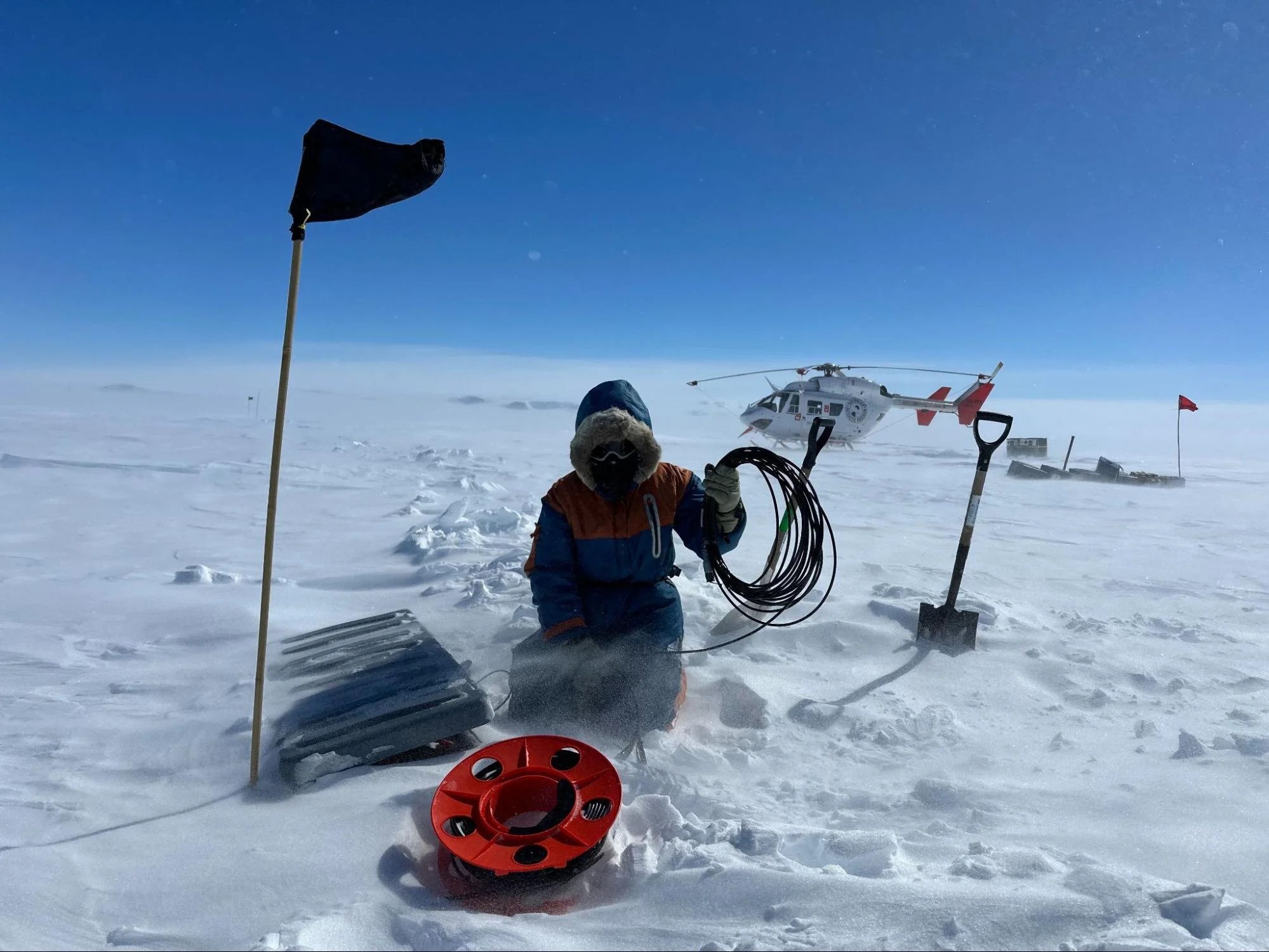
GRIT MT station installation on the Denman Glacier, enabled by GRIT Phases 2 and 1. Image: Maria (Coti) Manassero
Project Name
Geophysical Research Infrastructure for Antarctica (GRIT)
Project Leads

Timeframe
GRIT 3: 2025 - Present
GRIT 2: 2023 - 2025
GRIT 1: 2021 - 2023
Status
Active
Funding
AuScope Pilots 2
AuScope RIIP22
Hosts
University of Tasmania
Other Collaborators
Australian Antarctic Division
Additional Links
Antarctica's Denman Glacier is one of the most remote places on Earth - ABC News
Fishing for a glacier's secrets
AuScope Programs

Acknowledging AuScope & NCRIS
This project was made possible by support from the National Collaborative Research Infrastructure Strategy (NCRIS) via AuScope.
Acknowledging AuScope and NCRIS helps us demonstrate the value of shared research infrastructure, ensuring continued support and resources for the research community.
For examples of acknowledgment, please visit our ‘How to Acknowledge AuScope’.
We’d love to see your work—please tag us on social media using:
@auscope | #AuScopeImpact | #NCRISimpact