
Geodesy & Geodynamics Instrumentation
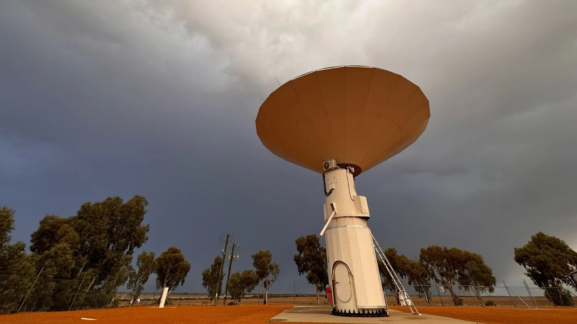
The 12 m Patriot Antenna used for Very Long Baseline Interferometry observations at the 2023_Yarragadee Geodetic Observatory. Image: Robert Nugent Geoscience Australia Artist in Residence
Very Long Baseline Interferometry (VLBI)
The AuScopeVLBI array comprises three 12 metre radio-telescopes at Mt Pleasant near Hobart, Yarragadee in Western Australia and Katherine in the Northern Territory. It underpins all space based observation, navigation and timing applications, and research in Australia because positioning relies on the VLBI enabled calibration of the global coordinate system.
VLBI observations in the Southern Hemisphere are particularly important because they directly support Australian science endeavours reliant on accurate spatial positioning.
The VLBI program completed the construction and implementation of the planned infrastructure in 2011, and today is used to observe for more than 150 days each year. System tuning and optimisation is ongoing to improve the quality of data received and speed of data transfers between the remote VLBI sites to correlation centers via high speed optical fiber connections.
Under contract to Geoscience Australia, The University of Tasmania operates the AuScope VLBI array with all data being provided to the International VLBI Service (IVS) to support the maintenance of the International Terrestrial and Celestial Reference Frames.
Satellite Laser Ranging (SLR)
The Yarragadee and Mount Stromlo SLR stations are ranked first and fourth in the ranking of all SLR stations. Collectively they contribute 25 percent of the global data volume collected from 38 stations.
AuScope investment in recent years has facilitated the upgrade of critical components at the Mt Stromlo SLR site, included larger power modules and increased laser pulse fire rates to enhance the ability of the system, by increasing the distance it can range to high-orbit satellites, permitting the GNSS system to be calibrated. This power upgrade significantly improved ranging to the GNSS constellations (GPS, Glonass, Beidou and the Galileo System) allowing both optical ranging via SLR and radiometric ranging via GNSS to the same satellites; this allows for direct technique inter-comparisons and system calibrations.
Global Navigation Satellite Systems (GNSS)
NCRIS funds combined with State funding built approximately 100 new stations; 55 of which were funded by AuScope. Distributed across continental Australia, each site has one instrument package, including a GNSS receiver, antenna and meteorology equipment.
The new stations have complimented the existing Australian Regional Geodetic Network and State networks, providing higher resolution to crustal deformation monitoring. This has a direct beneficial impact on the refinement of Australia’s Geospatial reference frame.
Gravity measurement (GM) instruments
Under the gravity program, an FG5 absolute gravimeter was acquired along with three gPhone Earth tide meters. An instrument calibration facility was also established at the Reynolds Dome in Mt Stromlo. The dome itself underwent renovations to function as a dedicated facility for gravimeter intercomparisons and calibrations.
The absolute and relative gravimeters facilitate regular gravity measurements at strategic locations across the country. These measurements help detect vertical land motion on a continental scale and capture variations in tidal gravity signals and are made available through a Geoscience Australia data portal. With upgrades to the gravity building at Mt Stromlo, the purchase of a relative gravimeter for ANU, and a portable FG5 absolute gravimeter, ANU and Geoscience Australia can collaboratively maintain the National Gravity Observation Program, providing national gravity data through observatories distributed across Australia.
Seven purpose built sites have also been constructed under the program for gravimetry measurements. Gravity at these sites, along with 8 others in the network, is observed semi-annually. gPhone observations have also been successfully conducted at various locations, including Jabiru, Katherine, Tennant Creek, Broome, Karratha, Warakurna (Giles), and the geodetic super site at Yarragadee.
Australian Geophysical Observing System (AGOS)
The establishment of an OBS fleet was an initiative of AuScope in 2014. The Australian National OBS Pool is operational and ready for use on a variety of projects by academia, government organisations and our industry partners. The units are stored at the Australian National University and can be accessed via an ANSIR request.
Magnetotelluric field instruments
AuScope’s Australian Geophysical Observing System funding (through the Education Investment Fund - EIF) augmented existing NCRIS AuScope infrastructure with new capability that focused particularly on emerging geophysical energy issues. AuScope AGOS infrastructure is used to enable the collection of new baseline data, including surface geospatial and subsurface imaging and monitoring data, thereby providing for better long-term management of crustal services, particularly in Australia’s energy-rich sedimentary basins.
The geospatial component complements the broader AGOS infrastructure platform that is focused on delivering the understanding of the physical state of the accessible crust of the Australian continent, which is crucial to meeting secure, sustainable future energy needs. Specifically, the capability has provided the research community with access to state-of-the-art geodetic instruments that support the highest precision measurement of deformation of the solid Earth. The AGOS geospatial infrastructure includes the following infrastructure investments.
Deployable GNSS instrument pool
The deployable pool of GNSS instruments for episodic campaign surveys in Australia includes 100 GNSS instruments, ten ionospheric receivers and three Real Time Kinematic (RTK) kits. The geospatial equipment is available for loan and is suitable for GNSS related geospatial and geophysical experiments. Whilst characterising the deformation of the Earth's crust is the targeted application of the equipment, other novel uses are encouraged.
This instrument pool is fully operational and well utilised. Users of the equipment include Geoscience Australia, Australian National University, The University of NSW, The University of Tasmania and the Australian Antarctic Division, with projects being undertaken in Australia, Indonesia and Antarctica. The GNSS instrument pool represents a significant capability to measure subsidence caused by crustal services, particularly those in the energy sector.
Geodetic antenna calibration
A geodetic survey mark network, including co-located radar corner reflectors, enables precise measurement of surface deformation at a regional scale using Interferometric Synthetic Aperture Radar (InSAR) and GNSS techniques. Both the radar reflector array (40 sites) and survey mark networks (65 sites) in the Surat Basin in Queensland were established to specification.
A broad scale experiment to measure subsidence was completed in 2022. The reflector array is currently being used by five individual space agencies for satellite radar mission calibration and validation.
Design and installation of new geodetic monument arrays
Four high precision GNSS CORS monuments were installed at Mitchell (Queensland), King Island (Tasmania), Blinman (South Australia) and at the Murchison Radio Observatory, Boolardy (Western Australia).
These monuments supplement AuScope’s GNSS CORS funded through NCRIS. The data streams from these stations are fully integrated into the AuScope GNSS array. The research community, government agencies and industry are using data from the stations to support precision positioning applications.
Geodetic antenna calibration
AuScope’s robotic GNSS antenna calibration facility is the only one of its kind in the southern hemisphere.
The facility includes two components: the outdoor robot facility located at Geoscience Australia in Canberra and an indoor anechoic chamber located at the National Measurement Institute (NMI) in Sydney. The NMI component of the GNSS antenna calibration facility is highly complementary to the robotic GNSS calibration facility. The infrastructure has enabled inter-comparisons between the two systems and has confirmed the operations of the Canberra facility.
The instrumentation has significantly improved the accuracy of crustal deformation measurements made by the GNSS instrument pool. Industry, academic and government partners routinely access the infrastructure.
Remote sensing data portal
An open-access repository of Synthetic Aperture Radar (SAR) data acquired by the European Remote-sensing Satellite (ERS) satellites over the Australian continent is suitable for InSAR analysis to detect ground surface deformation.
Data has demonstrated the value of satellite observations and significant interest in being generated in the capability. The NSW Government is currently constructing a GNSS and radar-monitoring network based on the AGOS design.
PROGRAM LEADER
Lisa Hall
Geoscience Australia
For more information on current and potential projects or to access AuScope’s Geodesy & Geodynamics infrastructure component, please get in touch with Geoscience Australia via clientservices@ga.gov.au.
COLLABORATORS
Geoscience Australia
DURATION
Since 2006
QUICK LINKS
AuScope VLBI Project Facebook Page
AUSTRAL VLBI observing program
AuScope geodetic VLBI array
The AuScope VLBI Project