
AuScope underpins Julimar polymetallic minerals discovery

The prize after decades of investment into geoscience data, tools and collaboration between government and industry? A mineral deposit discovery that will provide raw materials for clean energy technologies. Pictured: ore zone of the Julimar polymetallic mineral deposit on Wadjuk Country in Western Australia. Image: Chalice Mining
In November 2021, Chalice Mining Limited released a maiden resource statement for the Julimar polymetallic mineral deposit on Wadjuk Country in Western Australia. This is an exciting milestone for Chalice on the path to delivering palladium, nickel, copper and platinum for clean energy technologies. Equally impressive is the decades-long backstory to the Julimar discovery, which draws on government-supported data, tools and collaboration, with NCRIS enabled seismology at the heart.
Introducing Julimar
The Julimar Deposit (Julimar) is a polymetallic mineral deposit that is located on Wadjuk Country around
75 kilometres northeast of Perth in Western Australia. Buried just metres below Earth’s surface, it contains 530,000 tonnes of nickel (Ni), 330,000 tonnes of copper (Cu) and 53,000 tonnes of cobalt (Co), together with 10 million ounces of platinum group elements (PGE) including palladium, platinum and gold.
Chalice Mining Limited (Chalice) discovered Julimar in 2020 in a drilling program that aimed to locate base metals in what had previously been considered a greenfields geological terrain. It is Australia’s first major palladium discovery, so significant that it led to the West Yilgarn Ni-Cu-PGE (geological) Province naming.
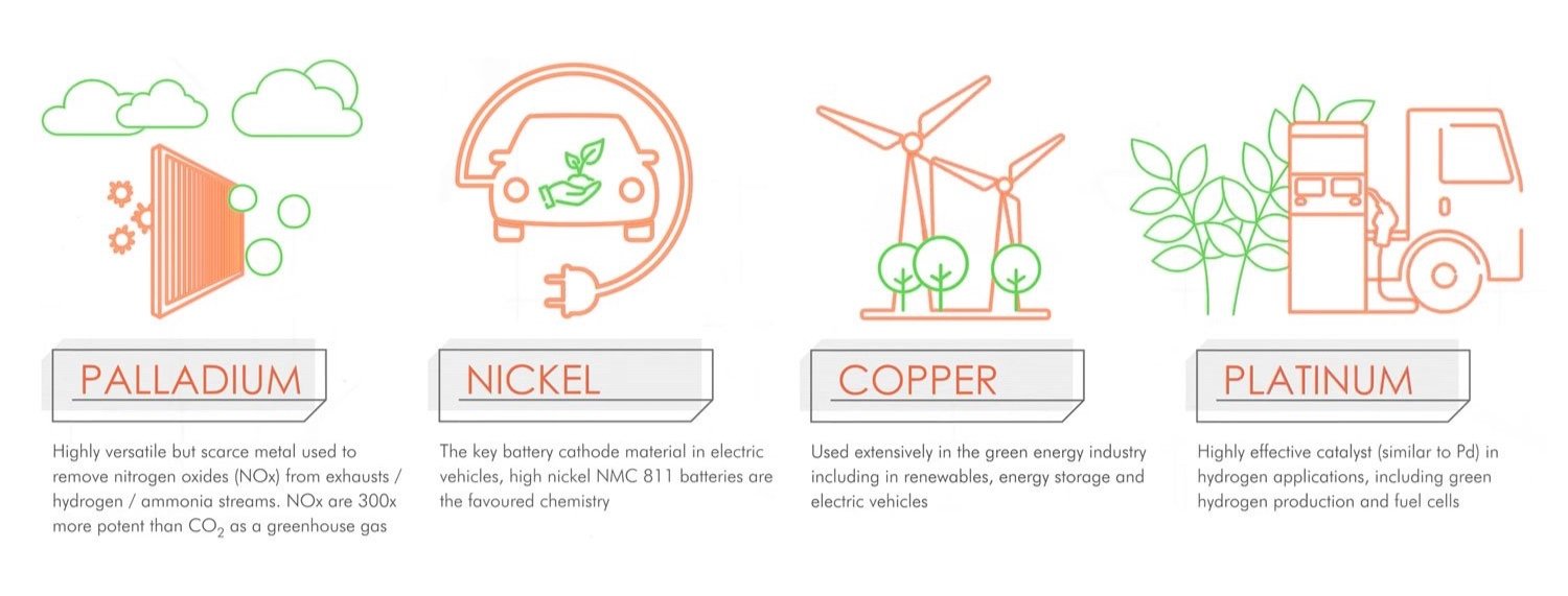
This mineral deposit discovery is important for all Australians since it contains some of the critical raw materials that make up a range of clean energy technologies. For example, palladium is a versatile but scarce |metal that can be used to remove greenhouse gas from engine exhausts, nickel is a key battery material in electric vehicles, copper is used extensively in renewables, energy storage and electric vehicles, and platinum is used in hydrogen applications including production and fuel cells.
Metals in the Julimar Deposit are key components of clean energy technologies. Image: Chalice Mining Limited
Research data, tools and collaboration at the discovery heart
Chalice stated publicly that a 2016 scientific report by Geoscience Australia (GA), and later, the Mineral Potential Mapper was the catalyst for the company to acquire the prospective exploration tenement.
Dr Karol Czarnota from GA explains how this report and tool both drew on decades of AuScope support for seismology data collection via The Australian National University (ANU) to help Chalise find Julimar:
“One of the inputs GA scientists drew on was AuScope and ANU seismic datasets which helped map the geological architecture and processes within the Earth around Julimar. Integrating the AuScope enabled architectural work with GA’s pre-competitive geological, geochemical and geophysical datasets was important to the quality of the assessment.”
In particular, the GA team relied on the AuScope enabled Australian Seismological Reference Earth Model (AuSREM). Czarnota expands on the geological processes that led to Julimar’s formation:
“Metals in Julimar have been sourced from a large area of molten rock located beneath the Australian tectonic plate. AuScope data has helped to map both the pathway that this molten rock took up to the near-surface environment where the deposit formed and its provenance. Identifying these features is an important ingredient in significantly reducing the search space for such deposits and increasing the chance of future discoveries.”

Map of Australia showing the minimum thickness of (mafic) geology in the crust, drawing in part on AuScope enabled seismology data (Salmon et al., 2013), that, in turn, enabled the Julimar polymetallic mineral deposit discovery on Wajuk Country, Western Australia. Image (modified): Geoscience Australia (Dulfer et al., 2016)
On behalf of the passionate scientific team at ANU Geophysics, Professor Hrvoje Tkalčić comments on the geoscientific data and modelling processes that ultimately contributed to the Julimar discovery:
“Our continuing efforts over the past decades have illuminated the interior of the Australian continent in unprecedented ways. In partnership with AuScope, our small but experienced team has achieved excellent results in delivering high-quality images and inferences for the entire Australian plate.”
A long game
As Minister for Resources and Water Keith Pitt rightly explains, minerals discovery is a long game:
‘Investing in pre-competitive data acquisition is a long-term game, but this case study [Julimer] shows how it can pay off. This announcement by Chalice clearly shows how pre-competitive data from Geoscience Australia can lead to discovery by industry.’
AuScope, together with partners at Geoscience Australia, State and Territory geological surveys, CSIRO – Mineral Resources, NCRIS capabilities and Australian universities, will continue to invest in research data to address national decadal geoscience challenges towards Sustainable Development Goals. If you would like to know more about these, please check out AuScope’s 10-Year Strategy 2020 – 2030.
Background: AuSREM & ANU
The Australian Seismological Reference Model (AuSREM) of the Earth's crust and upper mantle structure is critical for many tasks, such as the calculation of earthquake source parameters (location, magnitude, geometry), mapping the distribution of shaking after earthquakes, and the imaging of lithospheric dynamic processes. It was developed in 2010-2012 by AuScope and the team at ANU’s Research School of Earth Sciences (RSES) as a central repository for seismology information that provides a unified description of the structure of the crust and the upper mantle beneath Australia.
On behalf of AuScope, ANU also houses and maintains the national pool of portable seismic equipment (ANSIR, AuScope Earth Imaging Program). This collection includes a fleet of ocean-bottom seismometers and in-house developed data recorders. RSES also runs the Australian Seismometers In Schools (AuSIS) Program which captures passive seismic data in schools around Australia which can be used for both research and education purposes simultaneously.
RSES hosts the nation’s leading geophysics program and will continue nurturing leading-edge research into Earth's structure, composition, dynamics, and evolution, underpinning our ability to forecast its future. This includes understanding Earth's changing tectonic forces and threats from natural hazards, how Earth has evolved through time, and the relationships between the planet’s interior and the present-day state of the Earth’s surface, including the underlying controls on the distribution of natural resources.
AUTHORS
By Jo Condon, with contributions from
Dr Karol Czarnota, Professor Hrvoje Tkalčić and Professor Brian Kennett
and editing by Dr Tim Rawling.
ACKNOWLEDGEMENTS
Dr Karol Czarnota would like to acknowledge Dr Michelle Salmon
and Professor Brian Kennett from
the ANU Geophysics team whose
work significantly informed the
GA team’s analysis.
Professor Hrvoje Tkalčić is grateful to RSES academics, technical personnel
and PhD students for assisting in numerous field campaigns across
the Australian plate, and the research
contributions that illuminated it.
FURTHER READING
AuSREM: Australian Seismological Reference Model (Kennett & Salmon, 2013)
AuSREM: Crustal Component (Salmon, Kennet & Saygin, 2013)
AuSREM: Mantle Component (Kennett et al., 2013)
Potential for intrusion-hosted Ni-Cu-PGE sulfide deposits in Australia: A continental-scale analysis of mineral system prospectivity (Dulfer et al., 2016)
Julimar Ni-Cu-PGE Project (Chalice Mining Limited)
Exploring for the Future Fund supports Chalice’s historic
nickel sulphide discovery
(Minister Pitt, 2021)Major crustal boundaries of Australia, and their significance in mineral systems targeting (Korsch and Doublier, 2016).