
AuScope in Antarctica: Unlocking climate-response secrets hidden beneath the ice
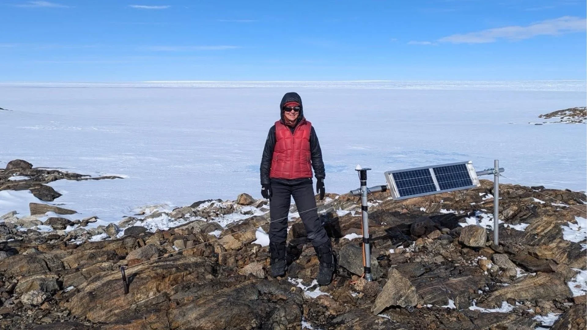
Professor Anya Reading (Field Leader) at a newly installed seismic recording site adjacent to the fast-changing Vanderford Glacier. The highly deformed Lower Vanderford Glacier can be seen in the background. Image supplied by Anya Reading (GRIT Director, Chief Investigator)
Antarctica holds clues about how our planet is responding to climate change, and what that means for our future. AuScope is helping Australian researchers uncover critical new knowledge, by building and deploying polar-rated instrument sets that can withstand Antarctic extremes, drilling deep beneath the ice to retrieve ancient sediments, and developing software for modelling how Earth’s topography and sea level respond to melting ice sheets. These NCRIS-enabled data and tools play a key role in preparing communities for the real-world impacts of a warming world.
The challenge
At the southernmost tip of the globe lies a continent that is key to shaping the future of our planet. Antarctica – vast, cold, and little understood – is melting at an unprecedented rate. Climate change is causing our oceans and atmosphere to warm, melting Antarctica’s shelves and outlet glaciers. This contributes to rising sea levels that threaten coastal communities, ecosystems, and infrastructure.
Researchers predict that sea levels will rise by at least 30 cm in the coming decades, but in reality, this value could be much higher. Significant knowledge gaps in how ice sheets will respond generate pressing questions: What glacier processes are important? Which outlet glaciers are changing rapidly? When could rapid accelerations of sea level rise take place? And, most importantly, how can we prepare?
To help answer these questions, AuScope is excited to enter the Antarctic research space, supporting a powerful suite of geoscience infrastructure and expertise to help build a more climate-resilient future.
Equipping science at the ends of the Earth
Antarctica’s vast, frozen terrain is notoriously difficult to study. To collect robust data, you need robust tools – and there is perhaps nowhere that this rings more true than Antarctica, where harsh winds, sub-zero temperatures, and logistical hurdles make it one of the most inaccessible places on Earth.
The Geophysical Research Infrastructure for Antarctica (GRIT) project, directed by Professor Anya Reading from the University of Tasmania, is meeting this challenge head-on. Supported by funding from AuScope, this project is deploying and upgrading dedicated scientific instruments tough enough to withstand Antarctica's extreme conditions, yet suited to rapid deployment in a variety of ice and rock settings.
The facility includes highly accurate Global Navigation Satellite System (GNSS) instruments – akin to GPS systems – that can measure subtle earth uplift over time, magnetotelluric (MT) instruments that are sensitive to the electrical structure of sub-ice and deep Earth, and seismic instruments that record ice and ground motion and the vibrations of ocean storms.
Professor Reading, who leads the facility and the seismology component, said the instruments can be used for many applications, from building detailed images of the Antarctic continent's deep structure to providing key inputs into models of ice sheet change.
For example, GRIT’s seismic instruments can be placed on or near active glaciers to record ‘icequakes,’ in a similar way to using earthquakes to understand active plate motions.
“Seismic data is powerful for monitoring glacier systems across extensive areas, as they respond to changes where their outlet ice shelves are being nibbled away by the warming ocean. We’re concerned about whether those glaciers are speeding up or if their motions are changing. But if we get a baseline understanding of the motion from the icequakes, then that puts us in a good position for monitoring future change.”
- Professor Anya Reading, GRIT Facility Director and Program 1 co-lead with The Australian Centre for Excellence in Antarctic Science (ACEAS) at the University of Tasmania.
Professor Reading said that another key application of seismic data is to probe the interface between ice and the rock beneath it, which can help inform ice sheet modelling.
“If you have ice on dry bedrock and it’s all frozen, then it’s like a car with good tyres on a dry road. But if you have a layer of soft sediment containing melt water between the ice and rock, then the ice can slide very easily, like a car tyre on a wet, muddy road. This means the ice dynamics will be completely different, which is crucial information to feed into ice sheet modelling.”
- Professor Anya Reading, GRIT Facility Director and Program 1 co-lead with ACEAS at the University of Tasmania.
Professor Reading and her team have surveyed locations across Antarctica that no one else has been to, providing unique data. One application of these datasets is determining the 3D structure of the deep Earth, which informs how the Antarctic continent will respond at different locations to the ice unloading. This work connects strongly with the work of Anya’s research team and the goals of the Australian Centre of Excellence in Antarctic Science (ACEAS), in collaboration with many Australian and international investigators. The data is made openly available so others can use it in their own research.
“The data that is collected has a pathway to being open access, so we’re helping to build data sets for the nation that can be used by other researchers into the future.”
- Professor Anya Reading, GRIT Facility Director and Program 1 co-lead with ACEAS at the University of Tasmania.
Alongside its suite of instruments, the GRIT Facility is also helping to nurture future generations of researchers by providing them with geophysics field skills training. Professor Reading said she hopes to pass on these skills to new researchers, giving them valuable experience they can build upon in future Antarctic expeditions.

Maria (Coti) Manassero field leader, left) explains how to optimise an MT (magnetotelluric) station electrode installation to Niam Askey-Doran (PhD student, right). Training a growing cohort of researchers in geophysics field skills is an important part of GRIT Facility activities. Image supplied by Anya Reading (GRIT Director, Chief Investigator).
Drilling into the past to understand our future
While instruments like those in the GRIT Facility are helping researchers measure and monitor how Antarctica is changing now, scientists also need to understand how it has responded to past episodes of warming. Unlocking that history means looking beneath the ice, and into the sediment layers that have preserved records of previous climate shifts over millennia.
The SWAIS 2C (Sensitivity of the West Antarctic Ice Sheet to 2°C) project aims to retrieve these records from deep beneath the West Antarctic Ice Sheet, helping to forecast rising sea levels and understand their impacts on coastal regions worldwide. Australia has joined the international efforts, with AuScope supporting the Australian & New Zealand International Scientific Drilling Consortium (ANZIC) and the International Continental Scientific Drilling Program (ICDP) in the deployment of new, low-cost drilling technology to retrieve cores from sedimentary deposits beneath Antarctic ice shelves and sea ice.
By sampling sediments deposited during the last interglacial period (~125,000 years ago), researchers aim to understand how the West Antarctic Ice Sheet responded to past periods when Earth was 1.5–2°C warmer than pre-industrial levels, a temperature range we are rapidly approaching today. This data can help us predict and mitigate future sea level rise.
When the ice melts, the Earth moves
However, collecting data is only part of the story.
To accurately forecast climate impacts, including sea-level rise, scientists must also understand how Earth itself responds to the shifting weight of ice and water at the surface, and how this redistribution alters gravity and sea level across different regions. This process is known as Glacial Isostatic Adjustment (GIA).
As massive ice sheets melt, the land beneath them slowly rises, while other regions may sink. This ongoing adjustment means that sea level does not rise uniformly like water in a bathtub: in fact, some locations can experience a relative fall in sea level.
Near former ice sheets, such as in Canada, Scandinavia, and Antarctica, the land rebounds upward as ice melts, causing local sea level to drop even as global oceans rise. Far from former ice sheets, such as in tropical and equatorial regions, the opposite effect occurs — the land can subside slightly, and sea level can rise more than the global average. This happens partly because the gravitational pull of the former ice sheet on nearby ocean water diminishes, redistributing water outward. In modern projections, GIA is expected to cause regional deviations in sea level of ±10–30 cm or more over the next century, depending on location.
Yet, until now, researchers have lacked the tools to accurately model this complex process. There are no openly available modelling frameworks that do not oversimplify the underlying physics – a gap that negatively impacts the accuracy of global sea-level projections.Professor Rhodri Davies, a computational and observational geodynamicist at Australian National University (ANU), said that:
“The mantle beneath East Antarctica is roughly 4 orders of magnitude more viscous than beneath West Antarctica. But what that means is when the ice melts beneath the West, the land rebounds very quickly, whereas beneath the East, the process is slower because the land is more viscous. We need models that incorporate that physics.”
– Professor Rhodri Davies, Computational and Observational Geodynamics in the Research School of Earth Sciences at the Australian National University
Supported by funding from AuScope and in partnership with ACEAS, Professor Davies and his team are setting out to change this through a project that aims to develop an open-source research software infrastructure that captures all key physics of GIA simulations.
“Most people run models and use the data just to validate them. We’re planning on using the data to drive the models such that the results are consistent with that data implicitly.”
– Professor Rhodri Davies, Computational and Observational Geodynamics at the Australian National University
This project builds on the existing G-ADOPT (Geoscientific ADjoint Optimisation Platform), developed through collaboration between 3 NCRIS facilities: AuScope, the Australian Research Data Commons (ARDC), and the National Computational Infrastructure (NCI).
“The tool allows us to connect the data streams of AuScope to the models. Often, they’ve operated in isolation – where you have data scientists collecting and analysing the data and modellers running models. Now, we’re really interfacing with those two fields, and that’s been a game changer.”
– Professor Rhodri Davies, Computational and Observational Geodynamics at the Australian National University
The tool is designed to be accurate, scalable and fully open source (https://gadopt.org/) to enable users from academia, government and industry to easily access and use it. By supporting this type of infrastructure, AuScope is helping Antarctic researchers improve the accuracy of sea-level projections and answer research questions across different disciplines, from groundwater modelling to the generation and preservation of critical minerals.
Example of a G-ADOPT simulation: Present-day thermal structure of Earth’s mantle, predicted from a global mantle convection simulation where the geographic distribution of heterogeneity is dictated by 230 million years of imposed plate motion histories from the AuScope-supported plate tectonics reconstruction software GPlates. The image shows a surface immediately above the core-mantle boundary (the inner sphere) and a cross-section of the mantle. It features isosurfaces (the blue and red blobs) where the temperature is lower (blue) or higher (red) than the radial average by 0.075 units, indicating the location of downwelling slabs and upwelling mantle plumes, respectively. Panel (a) provides an Africa-centred view, whereas panel (b) is centred on the Pacific Ocean and includes historical plate velocity data imposed from GPlates, represented by the green arrows at the surface.
Where Antarctic science meets storytelling
As AuScope deepens its involvement in Antarctic research, it is also committed to sharing these discoveries beyond the scientific community. This August, AuScope sponsored an activity at Hobart’s Beaker Street Festival – a science-art festival that includes events that spotlight Antarctic research and environmental monitoring.
Whether under ice or underfoot, the stories hidden in our planet are becoming clearer. Through cutting-edge tools and collaboration, AuScope is helping Australian researchers unlock the secrets of Earth’s most remote frontier, gaining insights that will shape how we respond to a changing climate.
Professor Anya Reading was recently announced as a 2025 ARC Laureate in recognition of her outstanding contributions to Antarctic and geoscience research. Congratulations, Anya, on this well-deserved achievement. Read the article to find out more.
Case Study
With support from AuScope, Australian researchers are combining NCRIS-enabled cutting-edge tools and data to reveal how Antarctica is changing — and what it means for our future climate.
Authors
Author: Alysha Huxley, Scientell
Editor: Daniel Vlahek, AuScope
Further information
Geophysical Research Infrastructure for Antarctica | Project Webpage
Australian Centre of Excellence in Antarctic Science (ACEAS)
SWAIS 2C (Sensitivity of the West Antarctic Ice Sheet to 2°C)
Australian & New Zealand International Scientific Drilling Consortium (ANZIC)
International Continental Scientific Drilling Program (ICDP)


