Data-Enhanced Virtual Laboratory (DeVL) project


Between 2017 — 2019, AuScope is leading a group of Australian research infrastructure organisations to culminate a vast collection of previously incompatible geoscience datasets, to allow researchers to ‘see through new glasses’.


The result for Australia will be improved earth monitoring, underpinning civil, mining, agriculture and environmental stewardship, as well as improved detection, extraction and protection of energy, water and mineral resources.

This innovative undertaking has been funded by $425,000 from Federal Government’s Australian Research Data Commons (ARDC), and supported by $440,000 of co-investment by the project’s collaborating partners*.

The project will be managed by CSIRO who developed the related AuScope Virtual Geophysical Laboratory and GRID technologies, in collaboration with Geoscience Australia and the State Geological Surveys.

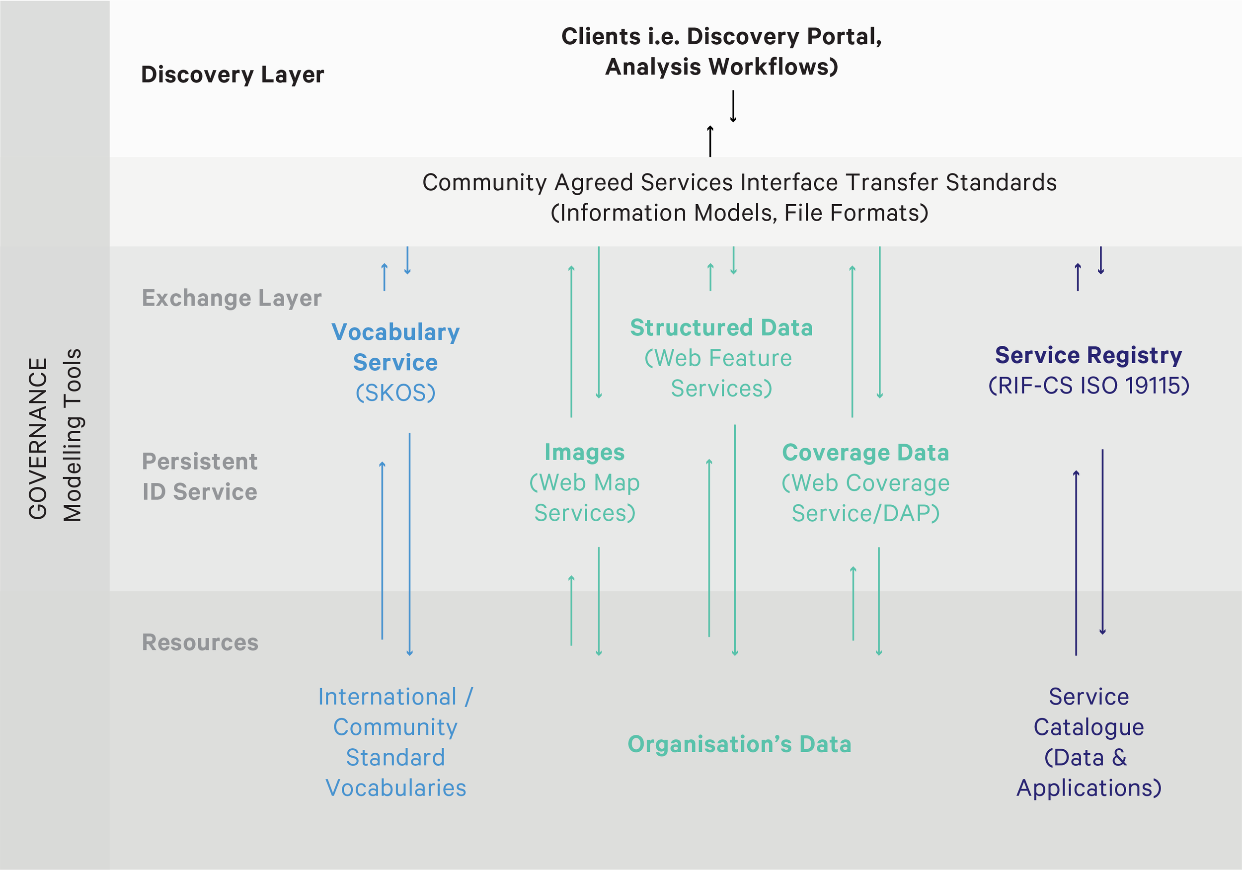
The first step in the five-year AuScope Virtual Research Environment (AVRE) plan is to build a Data-enhanced Virtual Laboratory (DeVL) that will provide researchers with seamless access to data, tools and compute resources via a single portal and related services.

AuScope CEO Dr Tim Rawling says the funding announcement has given AuScope the opportunity to meet the evolving needs of Australian researchers as they more deeply analyse increasingly complex geoscience data.

“This new initiative will enable a new capability for data discovery and computational analysis that underpins the next stage of innovation and scientific discovery,” he said.

“For a long time, we have been making data downloadable from a network of geological data stores, but to be able to bring together datasets from all over Australia into a single integrated Big Data platform, and transform the data to be ready for new tools, software and analysis methods is a huge step forward.”

AVRE and DeVL will boost productivity, says Dr Lesley Wyborn from the National Computational Infrastructure (NCI).


Background

The DeVL project builds on the AuScope Portal, the Virtual Core Library, the Scientific Software Solution Centre, and the Virtual Geophysics Laboratory, all heavily developed by CSIRO in collaboration with Geoscience Australia and the State Geological Surveys over the last decade.

The AVRE project extends the scope of existing eResearch infrastructure to capabilities and partners not previously involved in prior projects with AuScope and ANDS, Nectar and RDS.

This leads to a more coherent and integrated geoscience eResearch platform addressing a broader range of research sector and industry needs.

The project will enable the provision of new data types in a FAIR way (Findable, Accessible, Interoperable, Reusable). It will also utilise unique, International Geo Sample Number identifiers (IGSN) for physical geochemical samples collected by the academic community.

A driver for the creation of AVRE has been the 2016 National Research Infrastructure Roadmap which states that, to secure global leadership for the Earth Sciences over the next decade, Australia must now “enhance integration of existing data and mathematical modelling across large geographical areas to establish the next generation of ‘inward looking telescopes’ to better understand the evolution Earth’s crust and the resources contained within it”.


AVRE further reading


Background

In 2006 AuScope set out to change the way the Australian geoscience community exchanged and accessed data, both a technical and social challenge.

The Government geological and geospatial agencies of Australia, CSIRO and Universities have amassed substantial volumes of data, but were technologically challenged and limited in their capacity to store and dynamically access the data internally, and then deliver online to clients, partners and stakeholders. Further, the organisations developed individual data and information systems to meet their own internal business drivers, which resulted in heterogeneous systems that were unable to be linked together.

The original AuScope Grid achieved a breakthrough by taking a different approach to accessing data. Rather than trying to get each supplier of data to conform to a nationally agreed data model, CSIRO’s Dr Robert Woodcock and his team set out to create a unified system called the Spatial Information Services Stack (SISS) that enabled the exchange of data, with no change required in the underlying databases of the supplier; each data supplier would map from their internal systems to an agreed suite of exchange standards.

AVRE’s SISS showing the process of making data from heterogenous sources discoverable via the AuScope Discovery Portal.

AVRE’s SISS showing the process of making data from heterogenous sources discoverable via the AuScope Discovery Portal.

We have since successfully combined and made accessible historical and new data produced by AuScope and Australian Government geoscience and geospatial agencies, via a suite of data access products.


References

Woodcock, R.; Wyborn, L. Building the Australian Earth Science Grid, AuScope. Preview. 2007; 130:27.

Golodoniuc, Pavel; Klump, Jens; Woodcock, Robert. Leveraging AuScope technology to define distal footprints of mineral ore systems. In: AESC 2016 - Australian Earth Sciences Convention 2016; 26-30 June 2016; Adelaide, Australia. Geological Society of Australia (GSA); 2016. P.171.

Golodoniuc, Pavel; Woodcock, Robert; Wyborn, Lesley; Fraser, Ryan. Leveraging open standards and open data delivery. In: eResearch Australasia Conference 2016; 10-14 October 2016; Melbourne, Australia. Conference Organisers; 2016. 1p.

Golodoniuc, Pavel; Fraser, Ryan; Woodcock, Robert; Wyborn, Lesley. The Spatial Information Services Stack (SISS). In: eResearch Australasia Conference 2011; 6/11/2011; Melbourne, Australia. eResearch Australasia Conference 2011; 2011. 2.

Woodcock, R.; Simons, B.; Fraser, R. AuScope spatial information services stack - deploying an open source infrastructure for scientific spatial information interoperability. In: CSIRO Exploration and Mining, Kensington, editor/s. 3rd eResearch Australasia Conference; 9-13 November, 2009; Novotel Manly Pacific, Sydney, N.S.W.. 2009.

Wyborn, L.; Cox, S.J.D.; Woodcock, R. OneGeology : helping Geological Surveys worldwide to interoperate seamlessly on the next generation internet. In: CSIRO Exploration and Mining, Kensington, editor/s. Proceedings of the 33rd International Geological Congress; Oslo, Norway. 2008.

Cox, S.J.D.; Dent, A.; Esterle, J.; Woodcock, R.M.; Girvan, S.; Mackey, T.; et al. Standardized web-access to geoscience datasets: the SEEGrid WFS testbed. In: CSIRO Exploration and Mining, Kensington, editor/s. GIS and spatial analysis : Annual Conference of the International Association for Mathematical Geology : IAMG 2005, Toronto, Canada, August 21-26, 2005; 2005; Toronto, Ont.. Toronto, Ont.: International Association for Mathematical Geology; 2005. 844.


PROGRAM LEADER
Jens Klump, CSIRO

COLLABORATORS
CSIRO, Data61, University of Melbourne, University of Wollongong, Australian National University, Geoscience Australia and Geological Surveys of NSW, QLD, VIC, WA, TAS and NT and SA.

NCRIS initiatives: NCI, Research Data Australia, Australian Research Data Commons (ARDC), IMOS, TERN and ALA.

DURATION
Since 2006

QUICK LINKS
AVRE Store
Research Data Australia
DeVL Project

Petrophysical Tools


Field deployable instruments

Our suite of field tools observe and measure seismic activity, geothermal properties, and geophysical properties of Australia’s subsurface:

  • Surface and borehole seismometer fleets for ongoing observation of seismically active regions.

  • Broadband aftershock seismometers for rapid, and often remote deployment after significant events.

  • Distributed Temperature Sensor (DTS) – an AP Sensing optic fibre and laser-based instrument for short -term geothermal measurement programs to a maximum depth of 500m. For deeper (up to 1000m) and for longer deployments, we can provide a “disposable” fibre suited to permanent installation. 

  • Geo-DTS Sensing system with integrated heating loop, for in-situ determination of temperature, conductivity and heat capacity, and is designed for application in Enhanced Geothermal Response Testing.

  • Wireline temperature logger and natural gamma tool.

  • Gravity meter (gPhone) providing crucial baseline data for geophysical studies.

  • Trimble GNSS (Global Navigation Satgellite System/GOPS) receiver for collecting GIS and survey data for a range of geospatial applications. Capable of submeter/centimeter positioning accuracy.

  • Acoustic Televiewer (ALT) for structural profiling of boreholes.

  • Surface and borehole tilt-meters (Jewell/Lily) with application in volcanic and tectonic research as well as geomechanics.

  • Atmospheric monitoring tools (by Picarro) for application in the study of CO2/CH4 sources and sinks


Laboratory-based instruments

Our petrophysical and thermal analysis tools include:

  • Our primary analytical unit – the GeoTek Multi-Sensor Core Logger (MSCL) -provides the facility of continuous measurement of drill core to deliver petrophysics parameters thus yielding key information on the rocks of the upper crust. The MSCL delivers high resolution (at up to 1cm intervals along core) data on core density, p-wave velocity, electrical resistivity, magnetic susceptibility, and natural gamma production (including full spectra if required).  More recently we have added XRF analysis & colorimetry to the MSCL’s capabilities. 

  • Additional Petrophysical Analysis Capability suited to core sections and discrete samples

  • P-wave and S-wave velocity measurement using the “Pundit-Lab” instrument.

  • Resonance Modulus Testing to provide Young’s and shear moduli as well as Poisson’s ratio for geo-mechanical assessment of rock specimens.

  • Schmidt Hammer (Type L) for measuring uniaxial compressive strength.

  • Magnetic Susceptibility/Conductivity measurements using handheld instrument.

  • Magnetic Remanence meter (Q-meter) for collecting magnetic remanence and palaeomagnetic determinations from drill core as well as field specimens.

  • Optical thermal conductivity scanner (Lippmann-Raven instrument) enabling continuous scans on lengths of drill core to determine both the variability and overall estimate of thermal conductivity of the specimen.

  • Traditional laboratory-based thermal conductivity instruments – transient source (TK04) & modified transient plane source (CTherm -TCi) for measurements on solids, fragments and powders.

  • Tenney Environmental Test Chamber enable ng thermal measurements (such as conductivity) to be undertaken at a range of variable (-700C  to +2000C) ambient temperatures comparable to crustal warming effects.


PROGRAM LEADER
Dr. David Belton
Petrophysics Laboratory
School of Earth Sciences
University of Melbourne

COLLABORATORS
The Australian School of Petroleum, DETCRC and the CO2CRC; The University of Adelaide, WA and Melbourne; NSW, SA, VIC and WA State Geological Surveys; and CSIRO and Geoscience Australia.

DURATION
2006 – ongoing

ACCESS TOOLS & SERVICES
Dr. David Belton